Climate Research
See what’s happening in real time!
Impacts of climate change
“Human influence on the climate system is clear, and recent anthropogenic emissions of green-house gases are the highest in history. Recent climate changes have had widespread impacts on human and natural systems.” - IPCC Climate Change 2014 Synthesis Report [1]
"Climate" normally refers to the average weather in a given area, including the long-term patterns, typical conditions and variability. Expected weather and environmental changes around Tuktoyaktuk the coming century include changes to air and ground temperatures, more extreme and variable weather conditions, increased winter precipitation, less and thinner sea ice, changes to wildlife distribution patterns [2,3,4,5].
Possible future scenarios
We can’t be certain of how extreme the future effects of climate change will be, because they depend on not only the past and present, but also future human activity – whether we continue to produce greenhouse gas emissions at the same pace, or if we reduce these emissions. One way to represent the different scenarios is as Representative Concentration Pathways (RCPs). There are four pathways used to describe possible futures under climate change: RCP2.6, RCP4.5, RCP6.0, and RCP8.5 [1, 7]. The RCP number refers to the net radiative forcing, or the energy that is effectively trapped in the atmosphere by the greenhouse effect, in the year 2100. A larger number indicates more radiative forcing, and more extreme climate changes.
When incorporating climate change projections into building plans or risk assessments, best practice is to plan for the most extreme case. The most recent consultant recommendations for shoreline protection in Tuktoyaktuk [7, 8] use the upper limit of sea level rise and wave exposure projections under RCP8.5, and the median increased air temperature for the same pathway (see table below). Taking the high-end of possible climate change outcomes means that in the worst case the community will be sufficiently protected, and in the best case the shoreline protection will last longer than expected.
Below you will find a list of some of the most severe impacts of climate change to Tuktoyaktuk. To learn more, click on the links to access summaries of the impact, maps and access full scientific reports.

Climate Impacts
-
Coastal Erosion
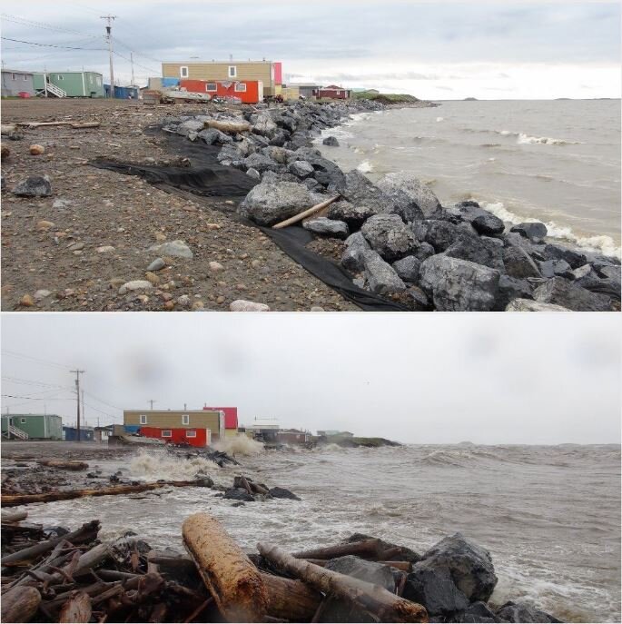
Tuktoyaktuk's west shore is retreating by an average of 0.3 to 3 meters per year, and during large storms can retreat by up to 5 meters over a few days. At this pace, the northern-most area of the community will be inaccessible by road by the year 2050.

-
Sea Level Rise
In Tuktoyaktuk, the median projected global mean sea level rise relative to 1986 is between 0.44 meters (RCP2.6) and 0.74 meters (RCP8.5) by the year 2100 [1]. Based on water levels recorded at the tide gauge in the harbour, sea level rise in Tuktoyaktuk has been reported between 2.4 and 3.5 millimeters per year since the 1960s [1,2,3,4].

-
Permafrost Thaw
Permafrost is ground that remains frozen for at least two years [1]. Tuktoyaktuk sits in the continuous permafrost zone, meaning there is frozen ground under 90-100% of the ground surface. Within the community, the upper 1.8 to 3.1 meters of soil (the active layer) thaws in the summer and re-freezes in the winter [2].

-
Sea Ice
Changes to the distribution of sea ice and length of the open water season will have important impacts on erosion and flooding, as well as seasonal temperatures, wildlife migration, and access to hunting and fishing areas [5,6,7, 8]. Since 1958, the annual sea ice cover over the Arctic has decreased and thinned, break-up begins earlier and freeze-up begins later in the year [9, 10, 11].

-
Flooding
Storm surge causes an increase in water levels, which results in flooding of the low-lying community. Rising sea level over the coming decades will cause even greater flooding in the community compared to what has been experienced in the past. Changing sea-ice conditions will also mean the community will be exposed to storm surge flooding for a longer period of the year.

Related pages
Climate Science Special Report
Canada’s Marine Coast in a Changing Climate, Full Report (2016)
Canada’s Marine Coast in a Changing Climate, CHAPTER 5: PERSPECTIVES ON CANADA’S NORTH COAST REGION (2016)
Adapting to Climate Change: Social-Ecological Resilience in a Canadian Western Arctic Community (2002)
The NCEP–NCAR 50-Year Reanalysis: Monthly Means CD-ROM and Documentation (2001)
Collapse of the 2017 Winter Beaufort High: A Response to Thinning Sea Ice? (2018)
From Science to Policy in the Western and Central Canadian Arctic (2015)
The next generation of scenarios for climate change research and assessment (2010)(Paid)
References
[1] IPCC. 2014. Climate Change 2014: Synthesis Report. Contribution of Working Groups I, II and III to the Fifth Assessment Report of the Intergovernmental Panel on Climate Change [Core Writing Team, R.K. Pachauri and L.A. Meyer (eds.)]. IPCC, Geneva, Switzerland, 151 pp.
[2] Burn & Kokelj. 2009. The environment and permafrost of the Mackenzie Delta Area. Permafrost and Periglacial Processes, 20, p.83-105. doi:10.1002/ppp.655
[3] Kokelj et al. 2017. Ground temperatures and permafrost warming from forest to tundra, Tuktoyaktuk Coastlands and Anderson Plain, NWT, Canada. Permafrost and Periglacial Processes. 28. doi: 10.1002/ppp.1934
[4] Berkes & Jolly. 2001. Adapting to climate change: social-ecological resilience in a Canadian Western Arctic community. Conservation Ecology. 5(2).
[5] Stroeve et al. 2014. Changes in Arctic melt season and implications for sea ice loss. Geophysical research letters. doi: 10.1002/2013GL058951
[6] Moss et al. 2010. The next generation of scenarios for climate change research and assessment. Nature, 463, 747-756, doi:10.1038/nature08823
[7] Baird. 2019. Tuktoyaktuk Coastal Erosion Study. Report for the Government of the Northwest Territories, Municipal and Community Affairs.
[8] Baird. 2021. Tuktoyaktuk Erosion Mitigation. Report for the Hamlet of Tuktoyaktuk and the Inuvialuit Regional Corporation.
