
1972: Department of Public Works assessment
Upon request from the Government of the Northwest Territories, the federal Department of Public Works (DPW) [6] conducted a borehole campaign and erosion assessment for Tuktoyaktuk, specifically to advise on shoreline protection for the school. The primary mechanism of erosion was identified as thaw subsidence, and that any shoreline protection strategy should address ground ice thaw.
Upon request from the Government of the Northwest Territories, the federal Department of Public Works (DPW) [6] conducted a borehole campaign and erosion assessment for Tuktoyaktuk, specifically to advise on shoreline protection for the school. The primary mechanism of erosion was identified as thaw subsidence, and that any shoreline protection strategy should address ground ice thaw.

Aerial image of Tuktoyaktuk in 1970. NRCan.
1976 – 1981: Longard tubes
Sand-filled synthetic fibre tubes installed in front of the old school to protect the shore and slow longshore transport. They were weakened by vandalism and waves, and eventually destroyed in 1981 [3].
Sand-filled synthetic fibre tubes installed in front of the old school to protect the shore and slow longshore transport. They were weakened by vandalism and waves, and eventually destroyed in 1981 [3].
Longard tubes installed as bulkheads on the shore. NRCan.
1986: Aveco report – Shoreline erosion protection, Tuktoyaktuk
To determine the most effective shoreline protection strategies, Aveco Infrastructure Consultants [3] first assessed the relative contributions of longshore transport, offshore transport, and thermal action to total erosion on Tuktoyaktuk’s shoreline.
They concluded that further use of groynes (longshore interception structures) would have little effect. Beach nourishment was recommended as a relatively low-cost method of insulating the permafrost to mitigate thaw and protect the shoreline. [3]
1987 – 1993: Beach nourishment
Beach nourishment replaces eroded sand and gravel on the beach, providing a limited buffer by "feeding the ocean" and preventing erosion from the natural slope [8]. The beach nourishment was reported as having failed in 1993.
Beach nourishment replaces eroded sand and gravel on the beach, providing a limited buffer by "feeding the ocean" and preventing erosion from the natural slope [8]. The beach nourishment was reported as having failed in 1993.
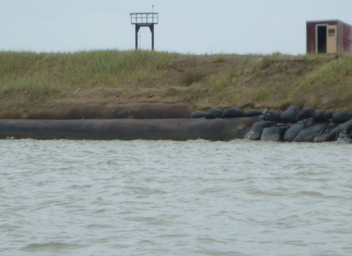
1986 – 1997: Sandbags
Sandbags were placed behind the cemetery to protect the beach nourishment area, and provided their own slow-leak beach nourishment as they broke open. In 1997, following years of minimal maintenance, a severe storm removed the sandbags from half of their original shoreline extent when waves washed over the sandbags and eroded the shore from behind [9].
Sandbags were placed behind the cemetery to protect the beach nourishment area, and provided their own slow-leak beach nourishment as they broke open. In 1997, following years of minimal maintenance, a severe storm removed the sandbags from half of their original shoreline extent when waves washed over the sandbags and eroded the shore from behind [9].

Sandbags piled on the shore. (NRCan)
1994: UMA report – Tuktoyaktuk Shoreline Protection Study
UMA [8] adopted the annual average shoreline change reported by Public Works, 1.8 meters per year, as a conservative estimate of erosion in unprotected sections, and concluded that without action the peninsula would lose road access by the year 2040.
Several possible solutions were proposed, including the least-cost option of gradual relocation of buildings and cultural sites off the peninsula, or a phased approach of protecting vulnerable test sections first. The community opted not to relocate, and instead to continue reinforcing the shoreline.
At that time, the community identified priority areas for protection (in order of most to least importance): the cemetery, residential housing, the school, industrial buildings, and commercial buildings.
1996 – 1997: Concrete footings
Concrete blocks measuring 1 m x 1 m x 0.25 m were placed on the shore behind the cemetery, along with the sandbags. They were undermined the following year by storms [4,10].
Concrete blocks measuring 1 m x 1 m x 0.25 m were placed on the shore behind the cemetery, along with the sandbags. They were undermined the following year by storms [4,10].

Concrete footings and sandbags. (NRCan)
1996 – present: Quarry stone / riprap
Graded quarry stone was placed on the coast in 1996 and 1997, although was damaged in the same year due to insufficient size and quantity for the wave exposure [4, 11]. More riprap has sporadically been added to over the years. The riprap currently in place varies in size and in some sections has been displaced from its original location [4].
Graded quarry stone was placed on the coast in 1996 and 1997, although was damaged in the same year due to insufficient size and quantity for the wave exposure [4, 11]. More riprap has sporadically been added to over the years. The riprap currently in place varies in size and in some sections has been displaced from its original location [4].
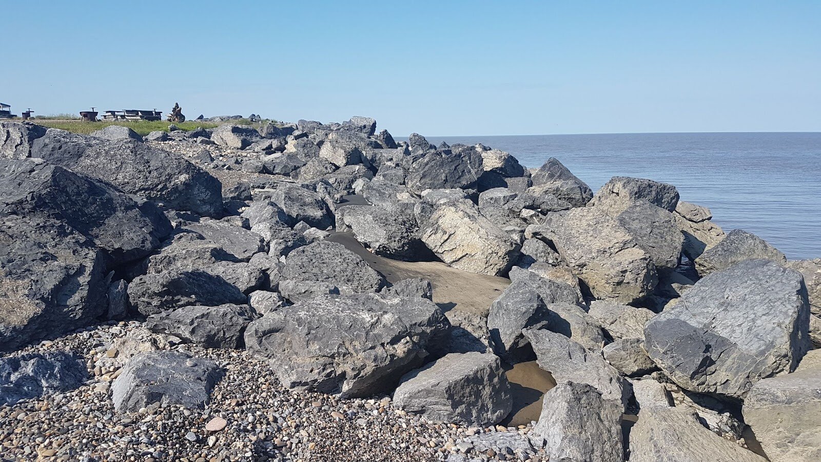
Riprap on the shore at Flagpole Point. (B.Berry, July 2021)
1997: Trillium report - Tuktoyaktuk erosion control using monolithic concrete slabs
In preparation to install monolithic concrete slabs which had been offered to the community [9], Trillium Engineering and Hydrographics Inc. [11] suggested a design to install the slabs that would protect the underlying permafrost from thawing and shifting, and would prevent undermining the structure. They also examined the existing riprap protection, and suggested reconstruction of shoreline protection in sectors where the sandbags had been washed away.
In preparation to install monolithic concrete slabs which had been offered to the community [9], Trillium Engineering and Hydrographics Inc. [11] suggested a design to install the slabs that would protect the underlying permafrost from thawing and shifting, and would prevent undermining the structure. They also examined the existing riprap protection, and suggested reconstruction of shoreline protection in sectors where the sandbags had been washed away.
1998 – present: Monolithic concrete slabs
Concrete slabs measuring 2.5 m x 10 m x 0.5 m were installed along approximately 100 meters beginning at Flagpole Point, along with a rip rap apron and splash pad [11]. The slabs continue to be effective, although Trillium reported that they would likely be overtopped during a 100-year storm event [6,11].
Concrete slabs measuring 2.5 m x 10 m x 0.5 m were installed along approximately 100 meters beginning at Flagpole Point, along with a rip rap apron and splash pad [11]. The slabs continue to be effective, although Trillium reported that they would likely be overtopped during a 100-year storm event [6,11].

Concrete slabs at Flagpole Point. (NRCan)
2019: Baird Report – Tuktoyaktuk coastal erosion study
To inform the design of upcoming shoreline protection structures, Baird [6] conducted a review of the baseline environmental, coastal hazard, and climate change information for Tuktoyaktuk. Due to the uncertainty surrounding the full magnitude of climate change impacts, they suggested an adaptive approach to shoreline protection which could be adjusted as future conditions become better understood.
To inform the design of upcoming shoreline protection structures, Baird [6] conducted a review of the baseline environmental, coastal hazard, and climate change information for Tuktoyaktuk. Due to the uncertainty surrounding the full magnitude of climate change impacts, they suggested an adaptive approach to shoreline protection which could be adjusted as future conditions become better understood.
2021: Baird report – Tuktoyaktuk erosion mitigation, preliminary design
A preliminary design and cost estimate for three possible shoreline protection structures, for both the west shoreline and Tuk island, was put forward in April 2021: concrete slabs, articulated concrete block mattress, or stone [12]. These designs have a recommended maximum lifespan of 30 years, contingent on proper (likely time- and cost-intensive) upkeep. In addition to placing more hard protection structures, sand and cobble beach nourishment and construction of a toe berm and splash pad along the shoreline (including existing concrete slabs) was also recommended.
A preliminary design and cost estimate for three possible shoreline protection structures, for both the west shoreline and Tuk island, was put forward in April 2021: concrete slabs, articulated concrete block mattress, or stone [12]. These designs have a recommended maximum lifespan of 30 years, contingent on proper (likely time- and cost-intensive) upkeep. In addition to placing more hard protection structures, sand and cobble beach nourishment and construction of a toe berm and splash pad along the shoreline (including existing concrete slabs) was also recommended.